SBG/
Westfield
ARCHIVE SITE![]()
New Site Here
Now it is about to open lets make it a party
Thursday 30 October 2008 - Doors to the Westfield shopping centre open to the public at 9am. London Mayor Boris Johnson officially opens the centre at 10.30am. Leona Lewis is meant to be cutting the ribbon with Boris in the massive atrium and performing at 11am. Meet to check out cycle parking etc at 9am [as below] before joining the razmataz.
Saturday 1 November 2008 - Lets have a party. Meet by Shepherds Bush British Rail station, next to the massive advertising panel, at 11am, for a ride around site, retail therapy and general fun. That is if it is open because they may have failed to put in the required number of cycle stands and so not have met their planning obligations.
contact John Griffiths 030 7371 1290 / 07789 095 748

We would like to see a safe passage for cyclists on the E-W / W-E corridor from the West towards Central London, and out again. Most of the planning for cyclists has been to get them into the complex. Westfield has taken the stance that the carriageway around Shepherds Bush Green is not suitable for cyclists.
On 19 June 2008 John Griffiths filed an objection against details of the Westfields Planning Applications. It is simple to follow with diagrams. The summary is below. Download the file as a pdf file [1.4Mb] or a Word doc [1.8Mb].
THE SOUTHERN
INTERCHANGE AND THE WESTFIELD CYCLING STRATEGY.
19 JUNE 2008
1 SUMMARY
1.1 I find several problems with the design involved with the Southern Interchange and with Westfield's plans for cycling. This paper should be construed as an objection to the planning applications. 2007/02266/FUL, 2008/01417/DET, 2008/01603/DET
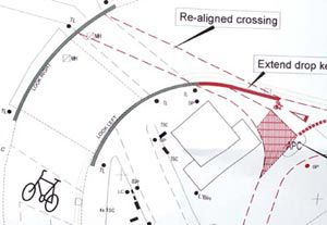
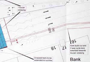
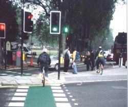
1.2 The method of taking cyclists off the carriageway of the Uxbridge rd presents a problem. At present cyclists on the main LCN+ route 73 into London are expected to leave the carriageway through the dropped kerb of a toucan crossing where pedestrians and other cyclists may be waiting to cross. I hope this may receive proper design care.
1.3 There are problems in the location of the toucan crossing. It is not in the most convenient place and those waiting to cross may block the flow on the footway.
1.4 There is a problem of whether the carriageway of the Uxbridge rd is wide enough to carry 4 lanes of traffic now that the footway has been widened. There is conflicting material in the planning applications.
1.5 There are fundamental problems concerning the lane widths on a curve, as a long vehicle on a bend requires a wider lane than normal. The toucan crossing acts as a break between two straight sections of the Uxbridge road. However the geometry actually constitutes a sharp bend in the road, with no lane markings. The Uxbridge rd [A4020] and Shepherds Bush Green [A402] are part of the Strategic Road Network [SRN], and the design guidelines call for much greater lane widths than shown.
1.6 This is an amazing opportunity for the Environment Department of LBHF to improve the urban space of Shepherds Bush. It could become a pleasant space that people enjoy being in and passing through, both as pedestrians and cyclists. It would improve health and reduce pollution and congestion. The Director for the Environment should be making this happen.
1.7 Some drawings
have been used from the LBHF planning website for the purpose of facilitating
this consultation. The originals can be accessed at
www.apps.lbhf.gov.uk/PublicAccess/tdc/DcApplication/application_searchform.aspx
and by putting in the relevant Application No, ie 2007/02266/FUL for
the SI application.
1.8 FROM:
John Griffiths, chair hfcyclists - local branch of the LCC in Hammersmith
and Fulham
122c Edith rd, West Kensington, W14 9AP, / 020 7371 1290 / 07789 095
748
www.hfcyclists.org.uk / john@truefeelings.com
If you wish to file an objection to these detail planning applications 2008/01417/DET, 2008/01603/DET, you have until 4 July 2008 to make a comment or objection on the LBHF planning website. [later comments might be accepted]
www.apps.lbhf.gov.uk/PublicAccess/tdc/DcApplication/application_searchform.aspx
Shepherds
Bush Green
CRISP
= Cycle Route Implementation and Stakeholder Plan
LCN+ = London cycle Network Plus
Overview
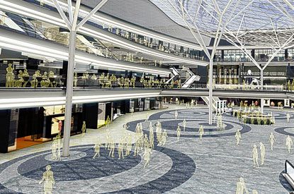
The number of cars wishing to pass through the Green may increase as Westfield's WhiteCity London comes on-line, set for mid-October 2008, but perhaps later. This has about 4500 car parking spaces.
There are other changes in the pipeline. The Southern Interchange is to be built betwen the present Central line station and the roundabout. [This is an area of bus stops, an interchange with the tube and a new rail station on the Olympia line]. This will introduce an large number of bus movements crossing between the interchange on the northern side and the southern [westbound] side of the road.
During the last year John Griffiths has been involved in meetings to develop the Westfield Cycling Stategy. Starting at Aug 07 below.
Recent develoments below. It looks increasingly likely that GRIDLOCK may become a common occurence.
A plan of the Southern Interchange, with instructions to see the original pdf on the LBHF planning site - see here - word doc
WESTFIELD RECENT DOCUMENTS
We would like to see a safe passage for cyclists on the E-W / W-E corridor from the West towards Central London, and out again. Most of the planning for cyclists has been to get them into the complex. Westfield has taken the stance that the carriageway around Shepherds Bush Green is not suitable for cyclists.
Following a petition from us delivered on 13 February 2008, there was a high level internal meeting at LBHF Council to discuss whether any changes could be made to the transport arrangements.
Our petition as a word doc
Cllr Nick Botterill's
response to our petition here as a word
doc
and our response
dated 3 April 2008 here as a
word doc or as a pdf
In preparation
for a meeting 18 January 08 John Griffiths sent the following to Westfield
Cycling Strategy Group, commenting on the Non -Motorised Users Audit.
See here
Following the
meeting another comment was sent saying that the modelling was based
on false premises of the space needed for queuing buses, and that the
Toucan crossing of the Uxbridge road could easily be made wider and
placed in a more suitable place.
See here
On 7 February 2008 we had a letter was published in the Hammersmith and Fulham Chronicle, informing the local populace of the potential problems for pedestrians and cyclists on the Toucan crossing. See here.
On 13 February 2008 we sent a petition to Cllr Nick Botterill, the Cabinet Member for the Environment at LBHF. See here.
SBG - November / December 07
On 26 November
2007 there was a meeting with
John Griffiths,
Tom Bogdanovicz of the central LCC
and officers from LBHF Highways dept.
to try and sort out cycling issues.
See
as a Word doc or as
a web page
On 3 December
2007 a file was sent to
Nick Morris, manager
of TfL's Network Management.
This asked for a review of the traffic modelling for the area, hoped
some problems would get resolved, and suggested considering a toll on
the car park to reduce the probability of gridlock.
See as a Word
doc
On 14 December
2007 John Griffiths received a letter from Cllr Nick Botterill
saying that Councillors will decide whether to agree Westfield's final
cycling proposals, as opposed to leaving it to the delegated authority
of Highways Officers.
see NB141207.pdf
SBG - August 07
The consultants Halcrow have produced a draft cycling strategy for Westfield, the developers of the WhiteCity London complex. This addresses the needs of cyclists entering the complex via segregated cycle tracks, but mainly ignores the problems that the Southern Interchange will bring to cyclists passing throught he area.
We have produced a response to this. See
WhiteCityResponse [produced 6 August 2007] as a pdf or Word doc .
A further response
was produced rapidly covering a further draft of Westfields Cycling
Strategy. This also addresses the possibility of congestion / gridlock
in the area. See
WhiteCityResponse28August as a pdf
or Word doc
There are planning applications filed with LBHF concerning the Southern Interchange and a variation for extra floor space at Whitecity. These can be accessed via instructions in the 6 August files above.
SBG - November 06
The Council is going ahead with a path on the northside of the Common. A plan of the general layout is available here, 183Kb. We have raised some concrerns about this. At the western end it may still encourage cyclists to go towards a blind corner. And it may lead to more pedestrian / cyclist conflict than occurs at present.
A refuge for cyclists at the Rockley rd crossing is being held back for further review.
SBG - April 06
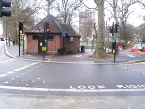
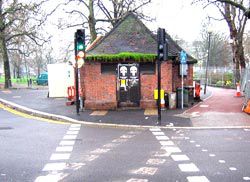
There was a meeting on 12 April 2006 with LBHF Highways engineers to discuss progress on works at SBG, at to see how the plans produced by the CRISP might have been revised. Dion Hallett of LBHF provided the above photo.
At the NW corner the path will now go to the south of the disused toilet block.
Some other aspects are still in abeyance.
SBG FINAL CRISP 1st Nov 05
In 2005 there was a CRISP study, meant to provide plans for high quality, safe cycle routes linking the Uxbridge rd with Holland Park avenue. We have been critical of the process. A further CRISP for the Uxbridge rd [Link 73] and covering SBG has been completed recently.
The council have completed the CRISP process for SBG.
We are not satisfied with the outcomes of the CRISP. At the hfcyclists meeting of 1 November 2005 we agreed 5 points were we raised objections and have written to LCN+ saying this.
The objections included the crossing to the north of the toilet block on a blind corner and in a space used by pedestrians, and the removal of a lane used by buses in a critically congested area.
Click
here for further details
SBG
draft CRISP

The LCN+ link 73 draft CRISP report deals with how the experts think a direct, safe and comfortable route can be delivered to SBG. Our rather critical response here [pdf file 460KB].
Our response includes
CONCLUSION: DOES NOT MATCH SAFETY CRITERION
Dropping cyclists into the outside of the fast lane of a three-lane one-way highway, and then leading them across the path of turning buses, does not match the criterion that the study should provide a safe route.
LCN+ London
Cycle Network Plus
CRISP Cycle Route Implementation and Stakeholder Plan
SBG NW corner [a bit historic]
Wood
Lane / Uxbridge road junction. This is now completed. There are problems
with the cycle route going directly into a disused toilet block. [the
dashed lines now lead you away from the toilet block, to the right of
it, but green paint on the road remains as a reminder - Nov 06] See
details
SBG SW corner
Shepherds
Bush Green - Goldhawk rd junction.
There are wide areas set aside for pedestrians, and restricted turns
allowed for cyclists. It would be more sensible to make the islands
shared use. We are pressing for this. See our detailed
observations.
As yet there is no coherent, well thought out, strategic safe provision for cyclists covering the area as a whole. Particularly should you wish to use the Holland Park roundabout.